We offer a private and secure workgroup within our app to manage crop protection tasks and foster collaboration within organizations. Our technology replaces inadequate and imprecise crop protection methods with a sustainable approach to agriculture modernization. By enhancing response times to crop anomalies, dispatching warning alerts, and delivering precise agriculture input guidance, agriculture workers can receive immediate and controlled information for reducing pre-harvest waste.
If you are an individual grower, crop advisor, or represent a small group of growers and crop advisors, the Workgroup is not for you. Instead, download our mobile app, and you will get all the benefits that we can offer without the need to create or join a Workgroup. Moreover, small teams might utilize all the collaboration features they need using our Team solution.
WHO IS IT FOR?
- Ag retailers and farming cooperatives – If you want to keep close contact with the farmers you serve, you can create your own branded Workgroup.
- Agripreneurs – If you provide consultancy for many growers, you can use Workgroup to enhance your precision agriculture offering and get assistance with managing the operation. You can monetize other services that you provide on top of that.
- Food producers and NGOs – If you manage a contract farming business, use Workgroup to manage your agronomy teams and provide growers with better support.
WHY DIGITIZE PLANT PROTECTION?
Digitized crop protection significantly changes how we interact with our environment by making communication readily accessible and the dissemination of information effortless. It allows better management of crop diseases, pests, and nutritional deficiencies. Agriculture experts no longer need to visit fields frequently. With remote sensing capabilities, observations are collected constantly, and decisions are made based on a large amount of data. This advancement results in more productive means of crop management.
OUR OFFERING
What is the Agrio?
Agrio is a web and mobile application that leverages artificial intelligence technology to close the gap in farmer-received support. Agrio facilitates modern plant protection adaptation and is easy to use, affordable, and scalable.
The software solution allows agronomists and managers to monitor fields remotely and be informed when intervention is needed. The solution is an end-to-end decision support system that allows agronomists to supervise greater acreage. By measuring operations and their outcomes on a large scale, we can provide evidence-based guidance, removing the guesswork from the challenging operation of plant protection.
We require minimal intervention from growers. Users draw their fields on the map, and we take it from there.
What is the Workgroup, and what makes it unique?
Workgroup is the world’s first secure and private channel for farming organizations and agri-entrepreneurs. It transforms Agrio from a public platform to an internal operations tool. The Workgroup enables users to create digital farming associations to manage crop protection endeavors on a large scale, with enhanced capabilities such as remote monitoring and area-wide integrated pest management. Workgroup is customizable and buildable; protocols and agriculture inputs can be predetermined and displayed to users within their channel.
How does it work?
Users create a Workgroup, assign Admins to the channel, and invite agriculture workers (e.g., farmers and crop inspectors). Communication and uploads in Agrio are only visible to those within the Workgroup. Admins can assign editors to customize treatment protocols and product details following the identification of crop anomalies.
What is the Dashboard, and what makes it unique?
Dashboard is a customizable digital extension software that organizes aggregated data from an Agrio Workgroup. The Dashboard arranges information for supervisors who want more thorough management of the crop protection activities within their organizations.
How does it work?
Dashboard interfaces in real-time with the activities of consenting parties within a Workgroup. Remote sensing data and alerts are visible in a way that allows easy reviewing. The Dashboard is fully customizable to meet the needs of each farming organization.
PLANT HEALTH CHECK
Artificially intelligent plant pathologist
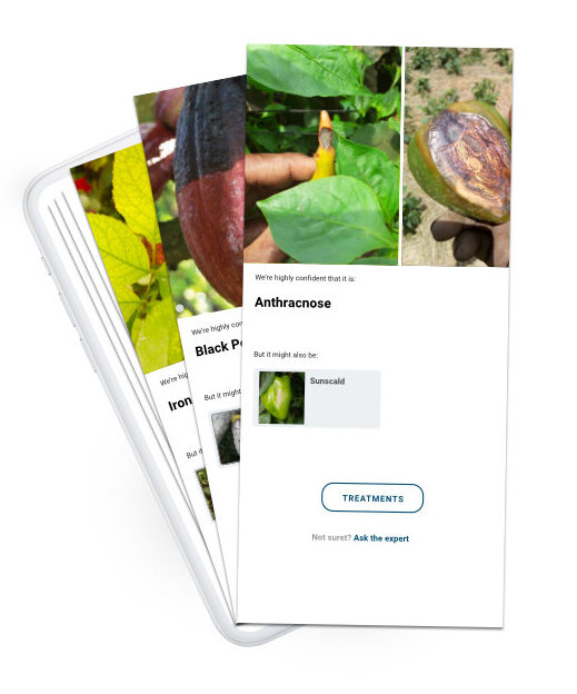
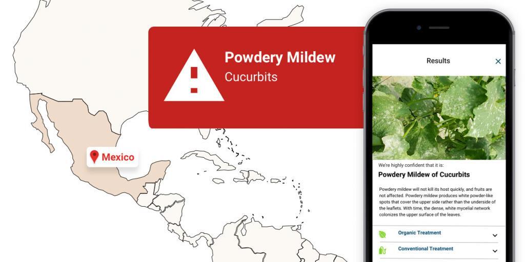
Farmers and inspectors can find it challenging to identify the correct pathogens, as well as to decide the economic threshold that requires a treatment program. Our solution enables users to rely on well-trained artificial intelligence algorithms to identify problems with their crops and decide on treatment necessities. If treatment is deemed required, our decision support system enables farmers and inspectors to follow a consistent scientific regime that optimizes pest management.
Our solution is plant-type agonistic. Pests and diseases have many hosts, and to model their spread, we need a good understanding of their presence on the entire spectrum of potential hosts.
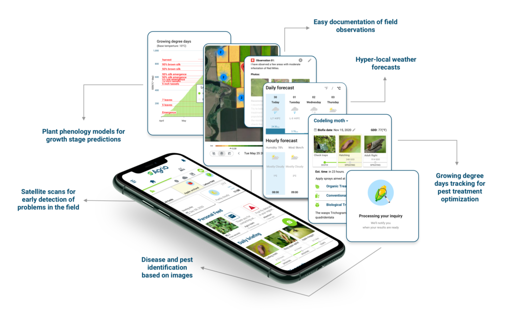
Users can snap a photo of their plants to receive a diagnosis and treatment recommendations.

Online machine learning
We developed artificial intelligence algorithms that can learn from a few examples and can learn quickly to identify new diseases and pests in new crops.
Agrio allows workers who are less experienced in plant protection to take an active part in the effort to keep plants healthy. Users can snap photos, and artificial intelligence diagnoses what is wrong in seconds. The images are geotagged and are used by the system to predict better the problems that might arise in the future.
Diagnostic support tool
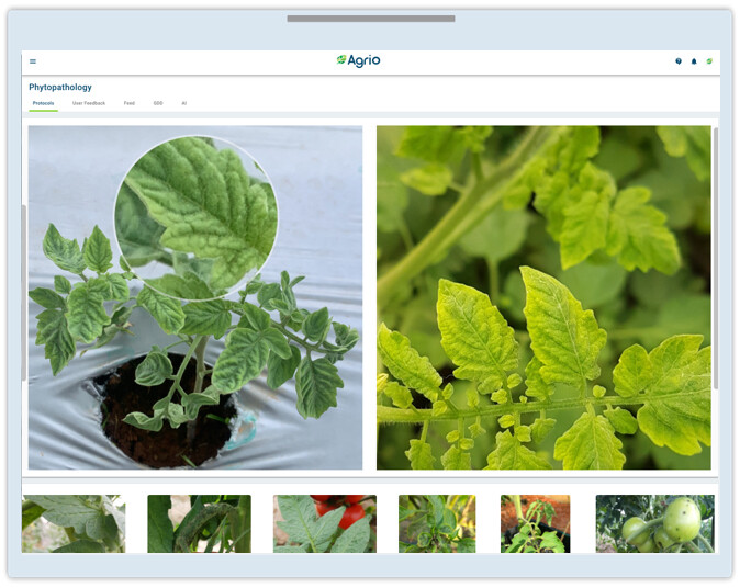
An easy-to-use diagnostic support tool allows supervisors to help growers when the artificial intelligence confidence is low. Supervisors can build a library of images of diseases, pests, and other crop problems. Photos in the library can be compared with users’ uploaded images to find matching symptoms and diagnose the problem. Once diagnosed, the diagnosis, together with treatment protocols, are sent to the growers.
The artificial intelligence system learns from the supervisors’ input and improves with time.
Easy-to-use training tool
Workgroup supervisors can use a simple user interface to facilitate the training. Once the system is presented with the images uploaded by supervisors, it will be able to identify new crop problems almost instantly.
The unique artificial intelligence capabilities built inside Workgroup are kept secured, allowing supervisors to gain a competitive edge.
Being exposed to millions of images, the Agrio artificial intelligence solution can differentiate different pathologies based on subtle changes in the symptoms patterns.
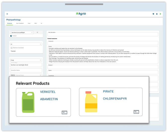
Customizable protocols and products
Supervisors can edit the treatment recommendations that are presented to growers. In addition, specific agriculture input products can be added as well. The product recommendations are served to users based on the crop, pathology, and geographic location.
Treatment feedback and optimization
Treatment outcomes are monitored with remote sensing data (such as satellite monitoring) and user surveys. Agrio presents efficacy insights to admins and suggests protocol improvements when needed.
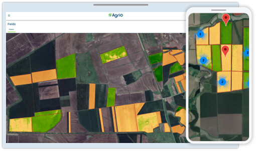
SATELLITE MONITORING
Field monitoring
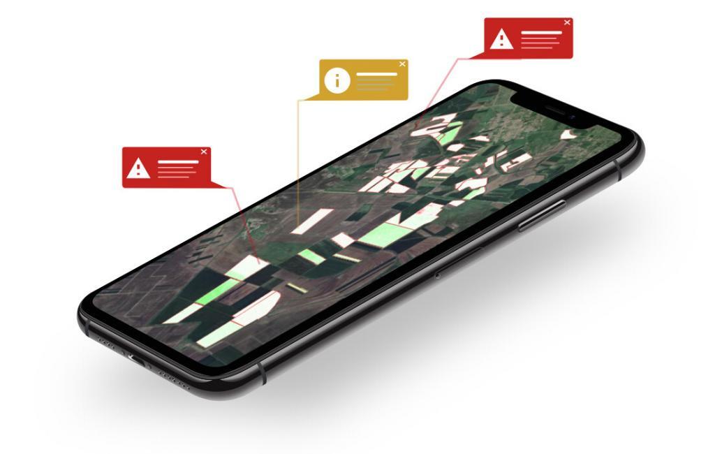
Monitoring crop progress and spotting problems in the field before symptoms are apparent is crucial for a successful harvest. Agrio makes such monitoring easily accessible to growers. Our solution supports multispectral imaging in various image resolutions and visits frequency.
We will show you how your last intervention affected the plants and guide you on which parts of the fields require inspection.
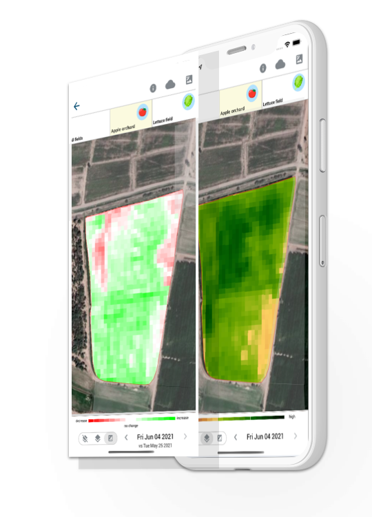
Leaf area and vegetation health
Some of the well-known indices, such as the NDVI index, is presented and tracked. The NDVI mainly correlates to the leaf area and allows us to estimate if the crop is developing at a good pace.
Chlorophyll concentration
NDVI shows a low correlation with the chlorophyll content, it is more severe in advanced growth stages when the NDVI becomes saturated. This saturation is due to the increase in the leaf area and the density of the canopy structure. In this stage, there is a need to monitor an index that is highly correlated with the leaf chlorophyll content and less sensitive to the leaf and canopy structure. The leaf chlorophyll content is an important indicator of plant health, photosynthetic potential, and nutritional state. Although extraction analysis by field sampling provides an accurate estimation of LCC status, such methods are not practical. Non-destructive remote sensing measurement offers an affordable and frequent way of assessing the LCC of plants over fields in high resolution. We do the image analysis and alert you when we find anomalies.
Monitor changes
To measure the impact of field interventions, we track the changes in the different indices. Users can see if leaf area and chlorophyll concentration improve or decline due to a problem. We compare subsequent satellite scans and can show changes up to day-by-day resolution. This feature allows inspectors to identify problems faster when compared to an inspection of the raw satellite data.
WEATHER MODELS
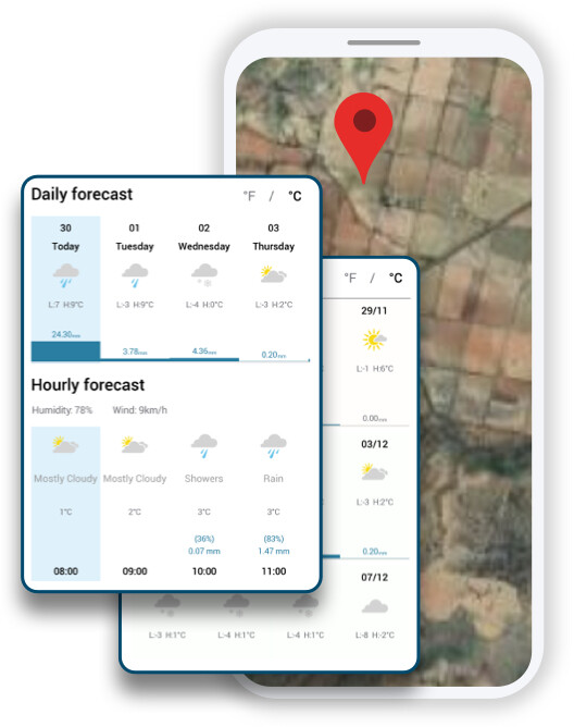
Hyper-local weather forecast
Weather conditions dictate plant behavior and development and strongly influence the emergence and development of pests and diseases such as the migration of insects, egg hatching, fungal spore development, sexual maturity, etc. Agrio makes precise, hyper-local weather forecasts readily available to all growers without the need to install any hardware.
Our prediction models combine weather measurements and observations from different sources. These state-of-the-art weather prediction models provide our growers an hourly hyper-local weather forecast explicitly designated to their unique area anywhere in the world; the forecast is provided at a 3km resolution, so it is specific to their fields.
We developed several models that use this information to track progress and alert when problems are expected.
Disease and pest forecast
Agrio dispatches warning alerts on impending infestations and sends written preventative measures to help users impede infestations. The alerts are based on images from all over the world that are being uploaded to Agrio daily. Moreover, we use weather models to predict plant disease and pest spread. Big data analysis helps us to provide pest migration forecasts, fungi spores spread estimation, and disease development predictions.
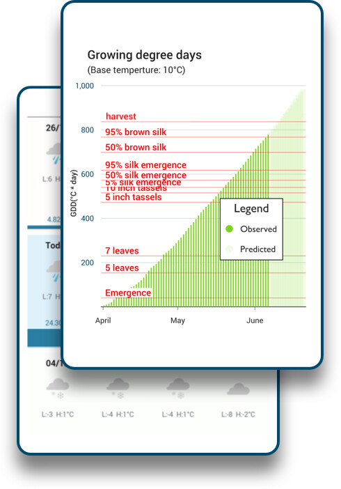
Phenology models
We constantly model plants, diseases, and pests and their interaction.
The development stage of the plant plays an essential role in plant protection decision-support systems. Monitoring the plant stage remotely allows us to provide more accurate preventative advice and help growers plan the sowing date to minimize disease and pest risks.
Growers can make the models better fit the plant varieties they grow by providing feedback on their plants’ development stage. The algorithms consider this information to fine-tune the models during the season.
We aggregate growers’ inputs and phenology stage estimations from satellite data to build localized, variety-specific prediction models that serve the entire workgroup.
We track the progress of plants and send alerts when development is not optimal.
SMART PEST TREATMENT
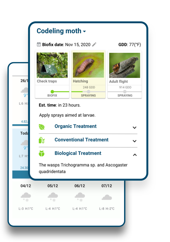
Weather-based treatment schedule
Weather models are used to predict insects’ migration, egg hatching, fungal spore development, sexual maturity, and more. Operations that aim to reduce the population density of a pest need to coincide with the high presence of the most susceptible life stage of the species in the field.
Weather-based modeling is more accurate than the calendar method in estimating the organism stage. Combining a weather forecast with a rigid phonology model brings a new sophistication to pests, diseases, and weeds management.
We compute the accumulation of the different environmental factors and feed them into our models. The digested insights are presented on the home screen. In addition, a daily briefing instructs growers on the required scouting operations and interventions in their fields.
These are updated in real-time with the progress of the weather conditions, observations in the field made by the grower, and observations made by other growers in relevant proximity. We present users with the optimal Integrated pest management treatment on time.
FIELD INSPECTION
Field scouting
Agrio enables inspectors to create digital screening reports straightforwardly and intuitively. The geotagged reporting is voice-based and does not require typing, allowing you to identify plant problems quickly, count insects, quantify disease and pest pressure, analyze pest traps, and record your insights while keeping your hands free. Reports are interactive and easily sharable, even outside the app.
When at the field, users can use this feature to examine satellite scans and navigate to places in the field that show problems. Pests, diseases, and other problems can be recorded. Visual works like insect counting in a trap can be done with a photo snap.
While inspecting the fields, inspectors can upload images of suspected symptoms, and our artificially intelligent agronomist helps with the diagnosis.
Scouting guidance
We provide notifications with instructions when we identify regions in the field that show stress. Analyzing the entire spectrum of wavelengths with algorithms trained on large datasets allows us to provide alerts before symptoms can be seen in the field.
Users are notified of high-risk locations.
Sharing the workload
Collaboration and communication are essential for the success of pest management.
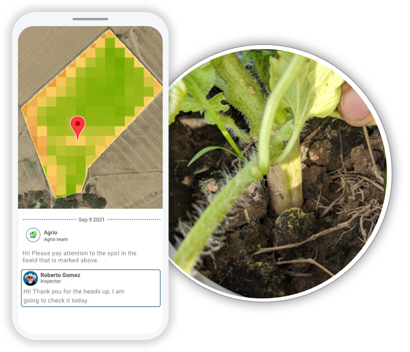
Users can create teams for each field to facilitate collaboration with colleagues. With their teams, users can examine remote sensing insights, alerts, and information collected during the inspection process and assign plant protection-related tasks to other members. This feature allows several inspectors to scout the same field with excellent coordination.
Members can examine the aggregated information and focus on the places in the fields that require attention.
We make it easier for users to communicate their findings with colleagues and clients.
In the field, inspectors create geotagged digital scouting reports. Team members can see the collected observations, get updates on the parts of the fields inspected by other team members, and plan the scouting route accordingly. Discussions on the required interventions are becoming easier within the team. Team members can define tasks, such as trap checking and spraying interventions, and be notified once other members complete tasks.
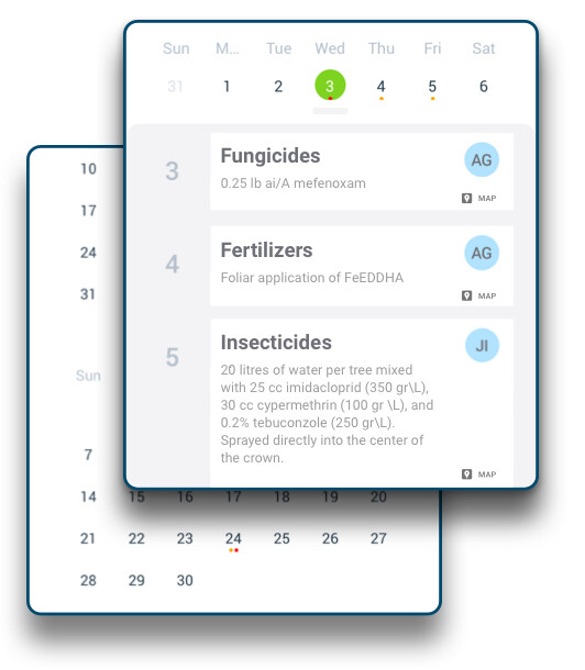
Interventions can be quickly recorded using the field calendar. We use this information to send you reminders and let you know when we have insights on which interventions worked better. Use this tool to create experiments with different interventions and monitor their progress.
JOIN US TODAY
Digitized crop protection significantly changes how we interact with our environment by making communication readily accessible and the dissemination of information effortless. It allows better management of crop diseases, pests, and nutritional deficiencies. Agriculture experts no longer need to visit fields frequently. With remote sensing capabilities, observations are collected constantly, and decisions are made based on a large amount of data. This advancement results in more productive means of crop management.
How to create your own branded Workgroup
Visit the trial page or start a 30-day free trial from our mobile apps. To start the trial from the Agrio app, go to the Workgroup section in the side menu and create your own Workgroup. It is straightforward, and in less than 30 minutes, you can have a fully functioning Workgroup. We are available to support you if needed.